WLS offers an invaluable resource to the energy industry: accurate & inclusive 3rd party oil & gas competitor leasehold and unit data, equipping you with the location intelligence you need to make educated, timely decisions. Let us help you bring added value to your organization’s business development and operational goals. Whether looking to jump start a new project or strengthen an existing one, our best in class data solutions will deliver the superior results you deserve!
PRODUCT OVERVIEW
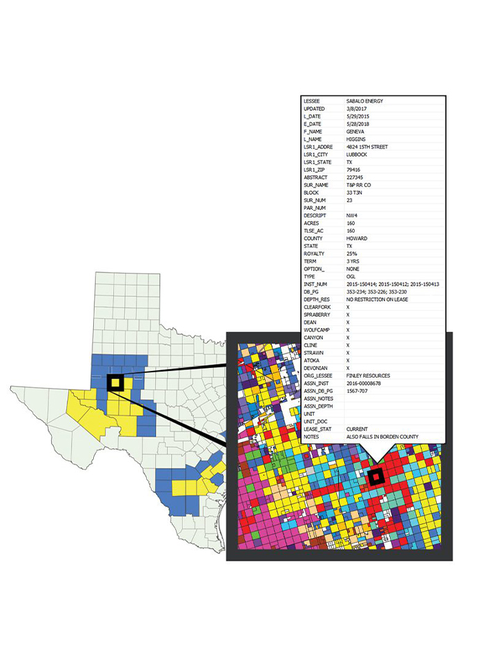
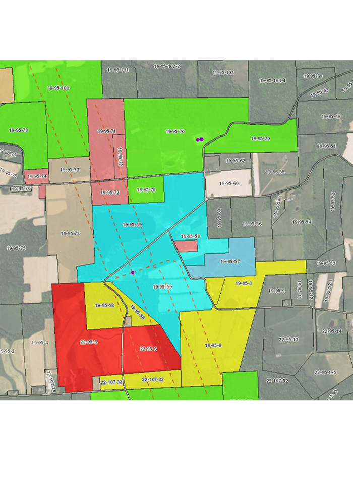
For over a decade, WLS has been servicing the oil and gas industry with its Competitor Lease and Unit data product. This offering reflects 10-20+ years’ worth of recorded oil and gas activity on a county-wide, per tract level, spatially capturing leases, assignments, releases, extensions, amendments, units, and other sundry type documentation. Whether you represent an E&P, Mineral Buying organization, Midstream group, Investment firm, or Non-Op, this resource offers tremendous value to your strategy discussions and decision making processes.
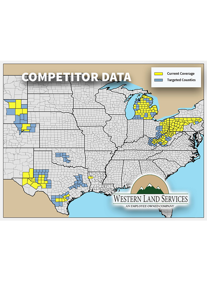
NATIONWIDE COVERAGE
- Over 2,000,000 Leasehold Records
- More than 90,000,000 Acres Digitized
- Over 30,000 Unit Boundaries
- And growing!!
PROCESS AT A GLIMPSE
- Document collection via physical or online courthouse system
- Digitize using ArcGIS as polygons, not points
- Manual mapping of all acreage no matter the threshold
- Consulting deeds and historic farm maps ensuring superior accuracy
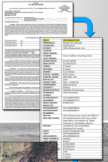
- Retain essential attributes including, but not limited to:
- Lease & unit statuses
- Lessee, lessor and operator names
- Lease effective & expiration dates
- Lease term & options including PUGH
- Acreage
- Landowner addresses
- Depth restrictions
- Assignment details including original lessee and ownership breakdown
- And more!

UsE CASES
Our goal is to serve up best in class location intelligence allowing YOU to make educated, timely decisions in a highly competitive market.
- Pinpoint A&D or JV opportunities
- Monitor competitor activity
- Evaluate lease expiration schedules
- Easily identify mineral owners and highly severed tracts
- Avoid HBP lands
- Identify lessees along existing and/or proposed pipeline routes
- Accelerate title, abstracting and due diligence efforts
- Query and manipulate data to support stakeholder decisions and strategic efforts
WHY WLS?
While WLS is not the only vendor that offers this type of data, customers have been choosing WLS for over a decade for many reasons!
- As a land brokerage company, we understand land best, and build / maintain our data with the end users’ needs in mind
- Every county includes lease AND unit data; and, offers a 10-20+ year lookback, offering the most complete picture in the market
- Query lessee ownership by major producing formations in our Western US geographies
- Robust attribute tables capturing critical data points
- Granular mapping = high quality and accuracy
- Custom deliverables based on YOUR needs
- No outsourcing or auto-mapping that compromises quality
- Our team is not only highly responsive, but enjoyable to work with!

deliverables
We offer a wide range of deliverables, from comprehensive data packages and web map access to simple Excel exports. While our data is traditionally priced by county, we can provide pricing by township/district, AOI, lessee, and other custom options. We are also now offering up more limited, nationwide access options per user.
- Shapefiles and/or geodatabase
- GeoJson
- Layer files
- PDF maps
- Excel files
- Feature and/or map services
- Web map access via COMPASS
- Data refreshed regularly!

partners
WLS is currently in the process of making its data available through a network of aligned partners. Keep a lookout for more information and news to come!!